Geoscientific information
National Land Commission Secretariat
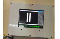
GNSS Stations (CORS) Category: Common
The Continuously Operating Reference Stations (CORS) Network provides Global Navigation Satellite System (GNSS) data, supporting three dimensional positioning, meteorology, space weather, and geophysical applications throughout the Bhutan.
Keywords: [#cors#station#dzongkhag]
National Soil Services Centre
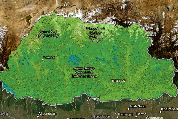
Soil Available Phosphorus Map of Bhutan Category: Common
This dataset contains the spatial distribution of soil available phosphorus content across Bhutan.
Keywords: [#Farming#Soil#Agriculture]
National Soil Services Centre
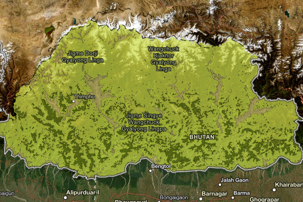
Soil Base Saturation Map of Bhutan Category: Common
This dataset contains the spatial distribution of Soil Base Saturation content across Bhutan.
Keywords: [#agriculture#soil#farming]
National Soil Services Centre
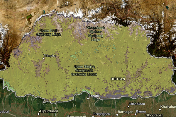
Soil Bulk Density Map of Bhutan Category: Common
This dataset contains the spatial distribution of Soil Bulk Density content across Bhutan.
Keywords: [#Agriculture#Farming#Soil]
National Soil Services Centre
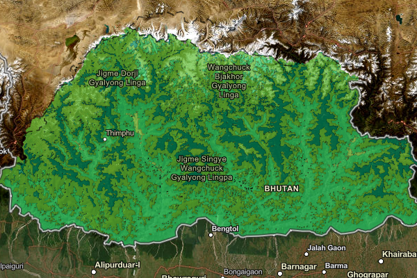
Soil Exchangeable Calcium Map of Bhutan Category: Common
This dataset contains the spatial distribution of Soil Exchangeable Calcium levels across Bhutan.
Keywords: [#Farming#Soil#Agriculture]
National Soil Services Centre
Soil Cation Exchange Capacity Map of Bhutan Category: Common
This dataset contains the spatial distribution of Soil Exchange Capacity levels across Bhutan.
Keywords: [#Agriculture#Farming#Soil]
National Soil Services Centre
Soil Exchangeable Magnesium Map of Bhutan Category: Common
This dataset contains the spatial distribution of Soil Exchangeable Magnesium levels across Bhutan
Keywords: [#Farming#Soil#Agriculture]
National Soil Services Centre
Soil Organic Carbon Map of Bhutan Category: Common
This dataset contains the spatial distribution of soil organic carbon content across Bhutan.
Keywords: [#Farming#Soil#Agriculture]
National Soil Services Centre
Soil Exchangeable Potassium Map of Bhutan Category: Common
This dataset contains the spatial distribution of Soil Exchangeable Potassium levels across Bhutan.
Keywords: [#Farming#Soil#Agriculture]
National Soil Services Centre
Soil Exchangeable Sodium Map of Bhutan Category: Common
This dataset contains the spatial distribution of soil exchangeable sodium content across Bhutan.
Keywords: [#Farming#Soil#Agriculture]
National Soil Services Centre
Soil pH Map of Bhutan Category: Common
This dataset contains the spatial distribution of soil pH content across Bhutan.
Keywords: [#Farming#Soil#Agriculture.]
National Soil Services Centre
Soil Total Clay Map of Bhutan Category: Common
This dataset contains the spatial distribution of soil total clay content across Bhutan.
Keywords: [#Farming#Soil#Agriculture]
National Soil Services Centre
Soil Total Exchangeable Bases Map of Bhutan Category: Common
This dataset contains the spatial distribution of soil total exchangeable bases content across Bhutan.
Keywords: [#Farming#Soil#Agriculture]
National Soil Services Centre
Soil Total Nitrogen Map of Bhutan Category: Common
This dataset contains the spatial distribution of soil total nitrogen levels across Bhutan.
Keywords: [#Farming#Soil#Agriculture]
National Soil Services Centre
Soil Total Sand Map of Bhutan Category: Common
This dataset contains the spatial distribution of soil total sand content across Bhutan.
Keywords: [#Farming#Soil#Agriculture]
National Soil Services Centre
Soil Total Silt Map of Bhutan Category: Common
This dataset contains the spatial distribution of soil total silt content across Bhutan.
Keywords: [#Farming#Soil#Agriculture]
National Soil Services Centre
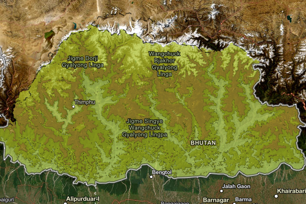
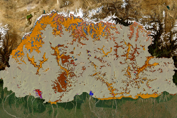
Soil Type (Class) Map of Bhutan Category: Common
This dataset is the soil type map of Bhutan. It represents the occurrence and distribution of different types of soils in Bhutan. The soil types listed in it are based on the World Reference Based (WRB) classification system of soil classification.
Keywords: [#Farming#Soil#Agriculture.]
National Soil Services Centre
Soil Available Potassium Map of Bhutan Category: Common
This dataset contains the spatial distribution of available soil potassium levels across Bhutan.
Keywords: [#agriculture#farming#soil]
Department_of_Geology_and_Mines
Source Monitoring Station Category: Open
The establishment of the earthquake monitoring station commenced in 2015 and was successfully completed in 2019. Its primary objective is to disseminate crucial earthquake-related information to enhance public awareness and preparedness. Recently, the Department of Geology and Mines (DGM) has been processing waveform data to verify earthquake occurrences. This analysis plays a vital role in generating a seismicity map, which helps identify regions prone to seismic activity. Furthermore, these efforts contribute to delineating possible active faults within the country, strengthening the understanding of Bhutan’s seismic landscape and supporting disaster mitigation strategies.
Keywords: [#Geophysics#Earthquake#station]
Department_of_Geology_and_Mines
Dzongkhag Intensity Meter Station Category: Open
To monitor and assess ground shaking intensity at specific sites during an earthquake, intensity meters are installed in every Dzongkhag. These meters detect seismic activity to support post-disaster analysis. Stations are primarily located in populated areas to facilitate effective response and relief measures in regions prone to severe damage.
Keywords: [#Earthquake Station]
Department_of_Geology_and_Mines
Gewog Intensity Meter Station Category: Open
To effectively monitor and assess the intensity of ground shaking during seismic events, intensity meters have been strategically installed across all gewogs, with the exception of four: Soe and Lingzhi in Thimphu Dzongkhag, and Laya and Lunana in Gasa Dzongkhag. These instruments are designed to detect and record seismic activity in real time, providing critical data that supports detailed post-earthquake analysis and damage assessment.The placement of these stations is prioritized in densely populated or high-risk areas to enhance situational awareness during emergencies. By capturing localized intensity measurements, they play a vital role in guiding timely and informed response actions, facilitating the coordination of relief efforts, and strengthening disaster preparedness in regions susceptible to significant seismic impact.
Keywords: [#Geophysics#Earthquake#station#gewog]
Department_of_Geology_and_Mines
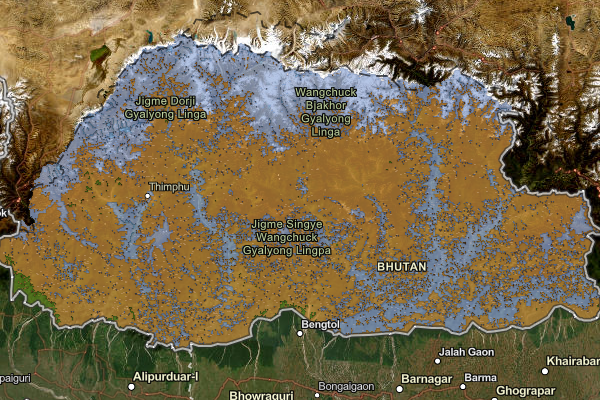
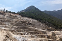
Location of Quarries in the Country Category: Open
Bhutan's mining sector primarily extracts industrial minerals like limestone, dolomite, gypsum, marble, ferro-silicon grade quartzite, iron ore, talc, and various construction materials. Due to favorable geological formations and easier market access, the majority of mines and quarries are concentrated in the southern foothills and lower Himalayas, with the central and northern high-altitude regions remaining largely inactive. The predominant extraction method is surface mining. Bhutan's mining policies are uniquely designed to balance economic prosperity with environmental preservation and social equity, aiming to promote in-country value addition and align the sector with the nation's development philosophy.
Keywords: [#mining#quarry#location]
Department_of_Geology_and_Mines
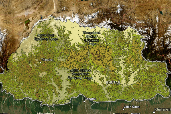
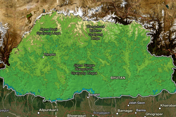
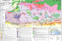
Geologic Map of Bhutan Category: Open
Featured in the Journal of Maps in 2011, this geological map presents a newly compiled 1:500,000-scale representation of Bhutan, along with neighboring areas in India and southern Tibet. Assembled from the most recent and comprehensive mapping datasets available at the time, it offers a significantly enhanced level of structural detail compared to earlier geological maps of the region. Bhutan’s geology is broadly categorized into four major lithological units, arranged from south to north: the Siwalik Group, the Lesser Himalayan Zone, the Greater Himalayan Zone, and the Tethyan Himalayan Zone. Alongside this, the antiformal tectonic window exposing Lesser Himalayan units with the Greater Himalaya, and the synformal klippe of Tethyan Himalayan units—both regarded as characteristic structural features of the Himalayas are also mapped in the Bhutanese Himalaya.
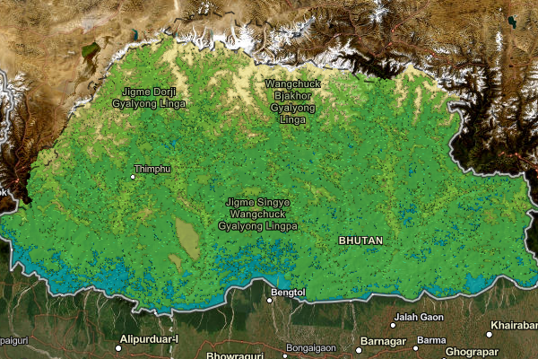
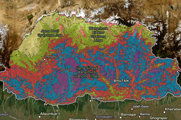
National Soil Services Centre
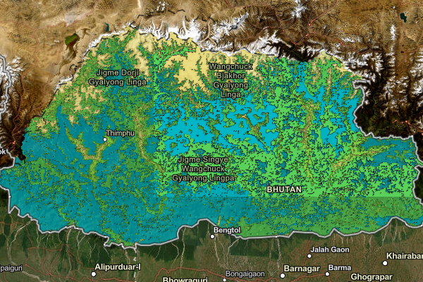
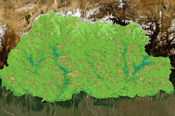
Soil Texture Map of Bhutan view Category: Common
This dataset is the soil texture map of Bhutan. It represents the occurrence and distribution of different types of soil texture in Bhutan. The USDA system of soil texture classification was used to classify different types of soil texture.
Keywords: [#Agriculture#Farming#Soil]
Department_of_Geology_and_Mines
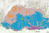
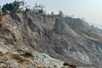
Landslide Inventory Map of Bhutan Category: Open
This inventory contains field-verified landslide point data collected between 2020 and 2025 from 15 Dzongkhags across Bhutan. The database was developed through remote sensing interpretation and field verification, with surveys focusing on landslides that pose risks to settlements, transportation networks, and critical infrastructure. The inventory shows a higher concentration of landslides in southern Bhutan, particularly in Samtse and Samdrup Jongkhar, while fewer landslides were recorded in Trashiyangtse and Lhuentse. The greater occurrence of landslides in the south is associated with fragile geology, major fault and thrust systems, and intense monsoonal rainfall. In contrast, many landslides in the northern and central regions are linked to road construction and other infrastructure development activities. The inventory provides a baseline dataset for landslide hazard assessment, susceptibility mapping, risk analysis, and disaster risk reduction planning in Bhutan. Limitations: The inventory primarily includes landslides with observable impacts on settlements and infrastructure. Due to accessibility and logistical constraints, some remote areas were not comprehensively surveyed. Future updates will incorporate these areas to improve the completeness of the database and strengthen landslide hazard assessments across Bhutan.
Keywords: []
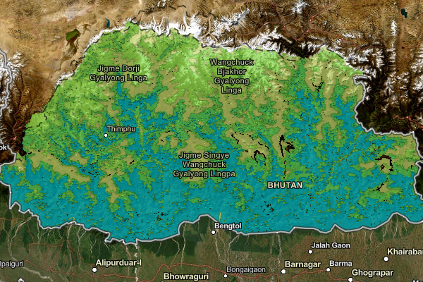
National Soil Services Centre
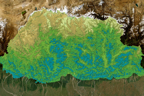
Soil Depth Map of Bhutan Category: Common
This dataset provides spatial information on soil depth of Bhutan. The map was generated through reconnaissance soil survey of agricultural land of Bhutan. The resolution of this map is at 30 meters, however, please use it with caution as the uncertainty level is high in some places, especially in forested area due to collecting samples only from agricultural land and also, the ground truthing is currently in progress.
Keywords: [#Soil#Farming#Agriculture]
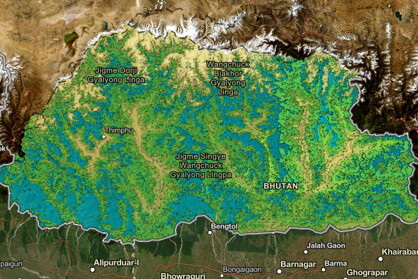
National Soil Services Centre
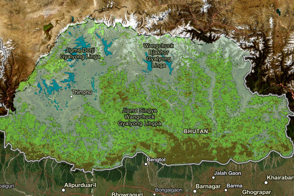
Soil Potassium Map of Bhutan Updated (Version 2.0) Category: Common
This map provides spatial information on available soil potassium content in Bhutan. The resolution of the map is at 250 meters, however, please use this map with caution as there could be high uncertainty in some areas, especially in forested areas due to limited samples from forested region and also, the ground truthing exercise is in progress. This data is to provide general overview of available soil potassium content in Bhutan.
Keywords: [#Soil#Farming#Agriculture]